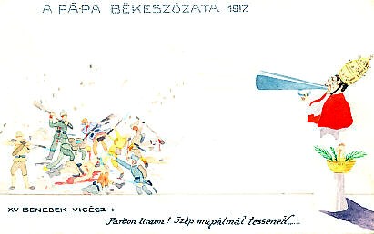
TimelineMapsSearch QuotationsSearch Images

Follow us through the World War I centennial and beyond at Follow wwitoday on Twitter

Image Search

This page uses cookies to store search terms.

Description Title Tags

Images found: 7

Description Text Tags
Map of the Theatre of War Operations on the Russian front showing the furthest (westernmost) advance of Russian forces and the Front as of December 1917 after the Russian armistice. From The War of the Nations Portfolio in Rotogravure Etchings Compiled from the Mid-Week Pictorial
Published by the New York Times Co.
New York City N.Y.
Copyrighted 1919 by the New York Times Company
1914 — 1919more Map of the Theatre of War Operations on the Russian front showing the furthest (westernmost) advance of Russian forces and the Front as of December 1917 after the Russian armistice. From The War of the Nations Portfolio in Rotogravure Etchings Compiled from the Mid-Week Pictorial
Published by the New York Times Co.
New York City N.Y., 1919.
Copyrighted 1919 by the New York Times Company
1914 — 1919
The War of the Nations Portfolio in Rotogravure Etchings Compiled from the Mid-Week Pictorial

Published by the New York Times Co.

New York City N.Y.

Copyrighted 1919 by the New York Times Company

1914 — 1919
Eastern Front, Carpathians, Carpathian Mountains, 1915-01-31, War of the Nations, Portfolio, War of the Nations Portfolio, New York Times, NY Times
Northern Egypt, the Suez Canal, and Sinai from Cram's 1896 Railway Map of the Turkish Empire.more Northern Egypt, the Suez Canal, and Sinai from Cram's 1896 Railway Map of the Turkish Empire. Egy[pt], Cairo, Penisula of Sinai, Gulf of Suez, Suez Canal, Suez, and other place names Egypt, Cairo, Penisula of Sinai, Sinai, Gulf of Suez, Suez Canal, Suez
What do you want here? Turkish and British child soldiers on the Suez Canal. After crossing the Sinai Peninsula during January, 1915, a Turkish army of approximately 12,000 soldiers reached the Suez Canal on February 2, and tried to cross after nightfall, but were driven back. On the 3rd, the British crossed the canal, and struck the Turkish left flank, driving them back. By February 10, the Turks had evacuated the Peninsula. 
Text:
Was willst Du hier?
Suez-Kanal
Reverse:
A.R. & C.i.B. No. 718/4more What do you want here? Turkish and British child soldiers on the Suez Canal. After crossing the Sinai Peninsula during January, 1915, a Turkish army of approximately 12,000 soldiers reached the Suez Canal on February 2, and tried to cross after nightfall, but were driven back. On the 3rd, the British crossed the canal, and struck the Turkish left flank, driving them back. By February 10, the Turks had evacuated the Peninsula. Was willst Du hier?


What do you want here?


Suez-Kanal


Reverse:

A.R. & C.i.B. No. 718/4
child soldier, Suez, Egypt, canal, Suez Canal, 1915-02-02, 1915-02-03, 1915, February
Austria-Hungary is being crushed by Russia, and Germany is hard-pressed to help while fighting France and Great Britain on the Western Front. By early 1915, Germany had repeatedly come to Austria-Hungary's aid in its war against Russia and Serbia. A postcard of a sculpture by Rizzi.
Text:
Un aiuto difficile
It's hard to help out
D.M. 527
Rizzi
Reverse:
I nostri soggetti sono depositati.
E' vietata qualsiasi reproduzione.
Our subjects are registered.
We prohibit any reproduction.more Austria-Hungary is being crushed by Russia, and Germany is hard-pressed to help while fighting France and Great Britain on the Western Front. By early 1915, Germany had repeatedly come to Austria-Hungary's aid in its war against Russia and Serbia. A postcard of a sculpture by Rizzi. Un aiuto difficile


It's hard to help out


D.M. 527

Rizzi


Reverse:

I nostri soggetti sono depositati.

E' vietata qualsiasi reproduzione.


Our subjects are registered.

We prohibit any reproduction.
France, England, Germany, Russia, 1915-02-01, 1915, February
Relief map of Great Britain and Ireland from the south with the North Sea, English Channel, Atlantic Ocean, and northwestern Europe: France, Belgium, Holland, and Scandinavia. The war-zone outlined on the map was declared on February 4, 1915. On May 7, the Lusitania entered the war zone southwest of Ireland.
Map Text:
Atlantisch Ozean, Nord-See, Kanal - Atlantic Ocean, North Sea, English Channel
Kriegs-Gebiets-Grenze - War-zone-boundary
Caption:
Westlichen Kriegschauplatz: Nr. 97. Karte III:
Die Gewässer um Großbritannien und Irland werden als Kriegsgebiet erklärt. Serie 47/4
Western front: No. 97 Map III:
The waters around Britain and Ireland will be declared a war zone. Series 47/4
Reverse:
Ausgabe des Kriegsfürsorgeamtes Wien IX.
Zum Gloria-Viktoria Album
Sammel. u. Nachschlagewerk des Völkerkrieges
War Office Assistance Edition, Vienna IX
For Gloria Victoria album
Collection and reference book of International warmore Relief map of Great Britain and Ireland, the North Sea, English Channel, and Atlantic Ocean, with northwestern Europe: France, Belgium, Holland, and Scandinavia. The war-zone outlined on the map was declared on February 4, 1915. On May 7, the Lusitania entered the war zone southwest of Ireland. Map Text:

Atlantisch Ozean, Nord-See, Kanal - Atlantic Ocean, North Sea, English Channel

Kriegs-Gebiets-Grenze - War-zone-boundary


Caption:

Westl[ichen] Kriegschaupl[atz]: Nr. 97. Karte III: Die Gewässer um Großbritannien und Irland werden als Kriegsgebiet erklärt. Serie 47/4

Western front: No. 97 Map III: The waters around Britain and Ireland will be declared a war zone. Series 47/4


Reverse:

Ausgabe des Kriegsfürsorgeamtes Wien IX.

Zum Gloria-Viktoria Album

Sammel. u. Nachschlagewerk des Völkerkrieges

War Office Assistance Edition, Vienna IX

For Gloria Victoria album

Collection and reference book of international war
map, Great Britain, England, Britain, Ireland, 1915-02-04, war zone, submarine war zone, 1915-05-07, Titanic, Brest, Cork, Falmouth, Plymouth, Portsmouth, Yarmouth, Cherbourg, unrestricted submarine warfare, British Isles war zone, 1915, February, St. George's Channel


1 2 Next